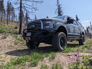
Completed my first trail! Saxon Mountain. Few snow patches but very doable. 11yr old son was a awesome spotter for when i was wimping out and worried. No damage other than a little striping. Last minute run on Tuesday!

Completed my first trail! Saxon Mountain. Few snow patches but very doable. 11yr old son was a awesome spotter for when i was wimping out and worried. No damage other than a little striping. Last minute run on Tuesday!


Looks like a good time was had.
Glad you got Out...
___________
In a never ending search for the proper mix of dirt & rock !


It's a trail that I don't think I've visited. `had to look it up. Some day!
Thx for the pix!


Very cool, Saxon mnt. was one if my first trails I ran in my sons 94 xj. I got into a pretty precarious situation at the one spot with that huge boulder you have go around (on my way back down the trail) real tippie.
It is so neat to see Goerge town lake from up there.
Glad you had such a good experiance. And nice rig!
Thanks guys! So much fun. Cant wait to get out with the crew!

Good times we're had it seems.
Saxon is a good time.
As well as the many connection trails
___________
Crazy- You call me crazy, but you wouldn't know crazy if Charles Manson was eating Fruit Loops on your front porch. Suiciadl tendancies- intatutionalized

I see that Saxon trail runs into Clear Creek MVUM:
https://s3.amazonaws.com/ClubExpress...Xc%2BkvnugA%3D
but is there a MVUM for the connecting road South Spring Gulch? The road is shown on the map, but not annotated to show what vehicles are permitted because it isn't part of the Clear Creek Ranger District?
The roads you comment on are ON / included on the Clear Creek MVUM. The MVUM is the "map". Perhaps I might be missing your intent of looking for a different "MVUM" for S. Spring Gulch.
From what I annotated on the MVUM, if that is what you are talking about, I take it as being a standard, county road. Just a typical road, likely gravel.
Yeah, thanks. I was just wondering cause I have a truck that is too wide for Saxon Rd (as noted above) but would take my dirtbike out there. If you look at the map, where Saxon Rd passes (from R to L) over the bold vertical (district?) line, it shows it as the dotted line on the other side - accessible to all vehicles. Now, it also shows 712.2A in that same area as the dotted line outside the district line (?) so, just wasn't sure if the OHV access ended right on the bold line or if there was a MVUM for some other "district" North of that bold line in the image you annotated. Sorry for having to describe. Don't have ANY decent image editing software on this computer :(. But thanks for the reply.


I understand the question, and the confusion.
On this MVUM, at the top right, is a legend that explains the shading, and the boundary markings. The line you are referring to does mark National Forest System Lands, which are the shaded areas on the MVUM. The unshaded areas are owned by anyone but the NFS. When you look closer, you will see many FS roads that cross over private property. They are still designated roads on the USFS travel management rule.
These maps will not show any State or County owned OHV areas. You have to do more homework for those.
___________
The Lost Boys motto: We don't know where we're going, but we'll be there for awhile. :)
for what it's worth... my guess based on link below, it's an OHV trail:
https://www.trailsoffroad.com/trails...h-spring-gulch
___________
The Lost Boys motto: We don't know where we're going, but we'll be there for awhile. :)
Jake (May 2nd, 2019)
 Posting Permissions

 Reply W/Quote