x


x
Max (May 3rd, 2017)

The last picture looks like an illegal bypass. Please stay the trail.
___________
Tom
-.- . ----- .-- - -.-.
Chris (May 3rd, 2017)

As Matt said, this trail was much harder and steeper than it looked. Definitely a challenging trail.
After this we continued down Switzerland Trail to Sunset where my GPS would suggest that there are a couple of bail out options. This turned out to be only partly true. Some roads were no longer through and blocked, and the other (Pennsylvania Gulch) was much harder than desired for the dark of night. The pics on traildamage do not do it justice. It was pushing the limits of my rig all while being extremely tight. I know Matt feels he chickened out, but he made the right call.
Props to Matt for being such a trooper and putting up with my poor choice in trail selection
Overall, it was a fun night
Also, I think the "off trail" pic is deceiving. That area was only being used to turn around so that he could safely drive down the trail. It is hard to get a sense of how steep that area is and how limited your bail out options were.
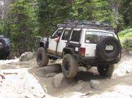

No need to get upset matt. Often times people create trails to get around snow drifts and then get back on the trail. Once the tire marks are there others tend to follow them and they end up looking just like that one did. It is not an always thing but typically grass in between tire marks is new trail that should not be there. If we use the excuse others used it we would find ourselves off trail a lot. Be careful, do research and have fun. Often times, especially with a big truck, you need to go slightly off trail to turn around or let others pass going opposite way but we want to prevent damaging the area around the trail. I have backed my way down a mile of trail before to get to a good turn around spot because of soft wet ground off trail that i would have dug into. Always err on the side of caution and research when you get home. Thanks for the pics.
___________
We do not remember days, we remember moments.
Cesare Pavese

--everyone please take my comments with a cool head-- I write them as if I'm saying this to ME (and I'm not going to have my temper kick in at myself).
Public Lands use is a sensitive topic. We, members of Front Range 4x4 hold OUR public lands as precious. We promote proper / sensitive use of our lands out of respect for others - this generation and many to follow.
Now, here is my overall thought regarding trail use.
These lands are OUR lands (mine as well as yours, individually and collectively). We MAY USE these lands as we see fit - BUT... We should use these lands with due care - out of courtesy for others who wish to use these lands (again, this generation and many to follow [read: two-tracks can take GENERATIONS to return back to an un-disturbed state from the point they are last used. Above timberline areas are considered the most sensitive by me.]).
I wish to enjoy trails and the scenery (or difficulty) offered. I don't desire to visit places that are "all tracked up" as it looks poor. I wish others didn't track the land up and make a degraded view for me. Now - this statement is understood that the finger points to me when I say "others". I'd better not needlessly track up an area out of consideration for others.
Where we have established trails - they're fair game to use / travel. Established trails are oft considered trails documented on MVUM's. I strive to hold to this but have in my past traveled an "undocumented" track. I do strive to "stay the trail".
As for "bypasses" - they happen as some people either blatantly don't care for others / care only for themselves [and will make a bypass where one did not exist] or for some grey area outside of staying on the established trail. When presented with an obvious bypass (a much lesser used side track) I strive to choose the main, established trail. If this means turning around as the bypass is open but the main track is snow blocked - so be it. It is this grey area area that can garner discussion with feeling and temper as we humans are different from another (which is good). One person would opt to NOT take a bypass where another would readily take the bypass. I'm not here to dictate to another what they should do as much as I don't wish to be dictated to. The purpose of this post is to lay out the issues at play where each of us may make an educated decision for how we wish to use our public lands.
We as a group strive to stay on the formal, established trail.
In photo postings _I_ (personally) desire to not see any "questionable" use posts. We are a public forum and those posts are public. We wish to promote courteous use of our lands for others (in our group) and to the world. Education and leading by example is the key.

Ran it today in the rain and grauple.
___________
Tom
-.- . ----- .-- - -.-.
Awesome! How did it go?
___________
Tom
-.- . ----- .-- - -.-.
video descent
https://youtu.be/NfyI3qSTLzU
___________
Tom
-.- . ----- .-- - -.-.
Wonder where this is. Its supposed to be of switzerland trail somewhere.
https://youtu.be/tvd3Gf02Nck
___________
Tom
-.- . ----- .-- - -.-.


Good question. I LOVE Colorado mining history and would love to check this place out. Guess I need to spend some time on google earth.

gotta love youtube:
yep watched that and couldn't really tell. also did a satellite google earth and couldn't tell.
___________
Tom
-.- . ----- .-- - -.-.
Pretty sure it's here:
https://www.google.com/maps/@40.0250.../data=!3m1!1e3
Tom (June 26th, 2017)
___________
Tom
-.- . ----- .-- - -.-.

Gotta love "secret" trails.
 Posting Permissions

 Reply W/Quote
")